Dry for this weekend. Temps remain above normal with good evaporation. We expect no interference from mother nature on harvest Saturday or Sunday.
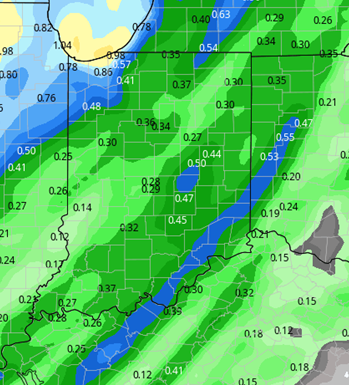
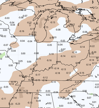
We do see some changes coming to the weather pattern starting early this week. Clouds will build through late Sunday night, and that leads to scattered showers Monday midday/afternoon and evening. The moisture potential is not that impressive, at a few hundredths to .6”, but it will end up with 80% coverage. WE think the higher end of the range will end up in central and southern Indiana, but we all see at least a little bit of moisture. night and Tuesday as a frontal boundary moves through the state. The map below shows potential from the frontal boundary.
We see clouds break on Tuesday, and stay partly sunny Wednesday, with no new precipitation. There is a high likelihood that a large part of the state can test the waters on harvest again in there, with Monday’s moisture not being impressive.
Thursday brings colder air to the eastern corn belt, as a front slowly sags across the great lakes. That differing air mass wrings some light moisture out. We can’t rule out scattered showers across the state, but only a few hundredths to .25”, coverage at 60%. The colder air is the bigger story. Temps will settle to normal and slightly below normal levels on Thursday, and then will be cooler Friday and Saturday, staying below normal. Daytime highs those days will be in the 50s and 60s, with lows near 40. No threat of frost.
South winds redevelop next Sunday, which till likely trigger a few more clouds again and maybe an isolated shower. However, significant moisture is not likely. Partly sunny and dry weather kicks off the following week for October 5th. However, temps look to be cooler for the start of that week too.
 Extended Period:
The extended 11-16 day forecast period is fully dry. Temps climb slowly Tuesday through Sunday (10/11). WE will move to above normal temp levels by midweek. There is no rain through the entire period, meaning we really have no major delay potential for harvest at this point.
Weeks 3 & 4:
More of the same. We are warmer than normal and drier than normal both periods. Temps will be a full 4-5 degrees higher than normal daily. Now, remember normal are falling off as we move into October, so daytime highs will be cooler. But, still, we see a pretty decent extension of warm weather. If we had moisture, we would be talking about an extended growing season…but the dryness has clipped our growing season on its own. We likely make it through the entire 14 day period for weeks 3 and 4 with only one good chance of rain.
Week 3
Precipitation (green: above normal, brown: below)
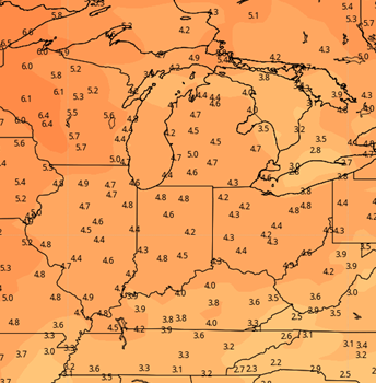
 Temperatures (blue: below normal, orange: above)

Week 4
Precipitation (green: above normal, brown: below)

Temperatures (blue: below normal, orange: above)