Your browser doesn’t support HTML5 audio
Not as “nice” of a harvest forecast this time around. We still will have opportunity, but a wide open window is not in the cards this week.
Colder air is settling in over the eastern corn belt this weekend. A strong upper level, low is working across the Great Lakes through the period. This will have strong rotation of clouds and atmospheric moisture down through at least the northern part of the state Saturday and Sunday, along with pulling down much cooler air out of Canada. We don’t expect large precipitation threats, but with the clouds we won’t rule out a few hit and miss showers, particularly Saturday.
Next week starts cool as well. After a drier Sunday and Monday period, we can see another threat of scattered showers Monday night into Tuesday midday…light totals, but it means we don’t dry super-fast. Then we get a good deal of sun late Tuesday and to start Wednesday.
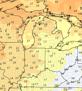
A warm front lifts into the northern part of the state late Wednesday afternoon, and that can trigger showers from US 24 north. The front parks over northern Indiana and southern MI through Thursday, bringing additional rain. Friday, the low associated with the front kicks out of the plains and rockets through the eastern corn belt, bringing rain and thunderstorms to the entire state. Rain totals from late Wednesday through Friday night will be half to potentially 2” with nearly 100% coverage.
Drier weather moves in for next weekend, but there is another surge of cold air coming out of Canada. So, while we are dry, we will be cooler than normal. Drying should pick up with a bump in evaporation later in the weekend, and we look dry to start the following week on the 16th.


Extended Period:
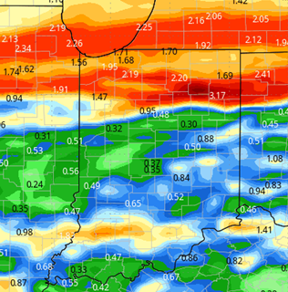
The extended period has our next large scale system arriving for the weekend of the 21st and 22nd, with rain and thunderstorms bringing threat of .5”-1.4” and 80% coverage. That would suggest we have a mostly dry window for the week ahead of that, although with warmer air trying to return, there could be some spotty instability to watch Tuesday-Wednesday. The weekend system does look to move slowly, as the main low is getting close to being cut off from the main steering of the jet stream.
Weeks 3 & 4:
Similar to last week, weeks 3 and 4 are near normal on precipitation, so we can expect at least one good frontal passage each week. Temps will be 2-3 degrees above normal on weekly averages, so the warmth relative to normal continues into early November.
Week 3
Precipitation (green: above normal, brown: below)
Temperatures (blue: below normal, orange: above)
Week 4
Precipitation (green: above normal, brown: below)
Temperatures (blue: below normal, orange: above)