
Another challenging 10-day window lies ahead of us for harvest. The weekend starts wet, at least in northern parts of Indiana, as a weather system races out of WI, coming across MI and northern IN on its way into OH for a direct hit there. Rain totals are not impressive at a few hundredths to a few tenths, but we clearly will not be drying.
The best rain potential lies north and east of a line from Rensselaer to Richmond. Areas that don’t see rain still will be dealing with plenty of offshoot clouds, meaning slow drying as well. Sunday strong north winds across the Great Lakes put temps below normal, and clouds will continue to dominate, although we can see some breaks, especially the farther south you go.
Monday, we have better sunshine potential, and temps respond as well. However, hit and miss moisture tries to return in northern parts of the state Monday night into early Tuesday morning, bringing a few tenths 40% of the area north of I-70. Farther south we see nothing. Tuesday features a mix of clouds and sun, clouds build late. Overnight Tuesday night through Wednesday a warm front brings showers to areas from I-70 north with 80% coverage and totals of up to half an inch. We won’t rule out scattered showers in the southern half of the state either, but coverage is far less.
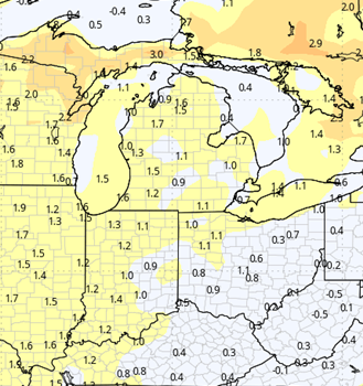
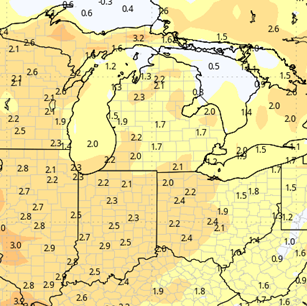
Thursday and Friday morning we take a break, but a frontal complex allows rain to return Friday afternoon through Saturday. Showers and storms can bring .25”-1” rains, and the potential for lingering clouds and drizzle even into early Sunday the 29th. This by far is not a friendly fieldwork forecast. The map below shows rain potential over the next 10 days into the October 30 time frame.

Extended Period:
The entire extended 11-16 day forecast window is dry on this new look. This will allow us to see a good harvest window from the period right behind that Ohio Valley system on forward. While we will be dry, we will only be seasonal on temps…meaning we are cooler, and drying may be a little slow at the start, depending on what locations see for rain totals this coming Friday-Saturday.
Weeks 3 & 4:
More of the same as we move through weeks 3 and 4. Temps recover to just a bit above normal for the middle of November, but precipitation stays in the normal ranges. That means we continue to see moisture moving through, rather than a longer dry stretch. That five day stretch from Nov 1 to 6 may be the best multi day window we see for the time being.
Week 3
Precipitation (green: above normal, brown: below)
Temperatures (blue: below normal, orange: above)
Week 4
Precipitation (green: above normal, brown: below)
Temperatures (blue: below normal, orange: above)