Your browser doesn’t support HTML5 audio
More dry air is on the way over the next 10 days in my Seed Genetics Direct Harvest Weather Forecast.
Strong high pressure is setting up over the SE US for this weekend and will not dissipate until next Tuesday. Strong southwest flow will take temps up through the next few days, allowing all of Indiana and Michigan to turn out warmer with full sunshine. Evaporation rates will stay at near maximum levels, while humidity is very low. This pattern holds through Monday.
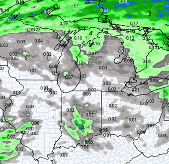
A system will be putting down rains through the weekend and next Monday in the intermountain West, central plains and into the 4 corners region. This system will finally kick out to the east next Tuesday and can allow for some clouds to develop in the eastern corn belt. However, this system runs out of available moisture quite quickly crossing Iowa and moving into the upper Midwest, so our threats of rain back here are minor.
We won’t rule out a few spits and sprinkles Wednesday, but only about 25% coverage with totals at a few hundredths to a few tenths. The bigger issue will be a change in airmass again, as Canadian air pushes southward across the Great Lakes in the way of that system. We are much cooler for Wednesday night along with Thursday and Friday of next week. However, we should see good sunshine and strong drying again.
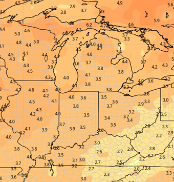
Temperatures climb to finish the 10-day forecast window next weekend into Monday the 28th. We can be a good 15-20 degrees above normal. That leads to a very dry set up again, allowing harvest to progress full bore. The map below shows combined 10-day moisture potential for the entire region as we are seeing it currently.
Extended Period:
The extended forecast period shows a strong cold frontal passage for late Tuesday the 29th through Wednesday the 30th. Rain and thunderstorms are likely as there will be very warm air ahead of the front. Rain totals can be from .25”-1.5” with coverage at nearly 100% of IN and a80% of MI. Behind the front we turn cooler to finish the week and start November but still are likely a bit warmer than normal.
Dry weather will be seen for Halloween and Friday the 1st. But another frontal passage is likely for Nov 2 into Nov 3, which can bring another half to 1.5”.


Weeks 3 & 4:
Temperatures remain above normal for weeks 3 and 4, averaging 5-6 degrees above normal in week three, and 3-5 degrees above normal for week 4. Precipitation gets closer to normal for both weeks, and a bit of a wetter pattern is trying to take shape just to our west.
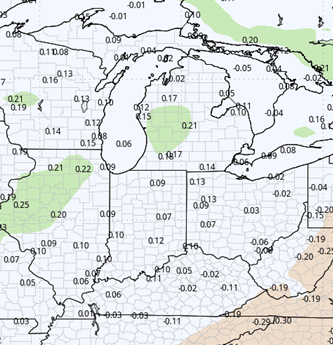
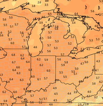
Week 3
Precipitation (green: above normal, brown: below)
Temperatures (blue: below normal, orange: above)
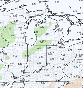
Week 4
Precipitation (green: above normal, brown: below)
Temperatures (blue: below normal, orange: above)