
We start off with a mostly dry weekend over the Hoosier state. Some clouds will hang around on Saturday, but Sunday turns out mostly sunny. The dry pattern holds Monday as well, where we see our warmest day of the week and of the pattern. Temps will be above normal. There is a significant system passing by to our north over Michigan and the Great Lakes, so northern parts of Indiana will need to watch for some clouds as an offshoot of that. However, we are keeping precipitation farther north.
Tuesday features a mix of clouds and sun, but we also bring temps down just a bit. The best threat of moisture over the next 10 days shows up next Wednesday into early Thursday.
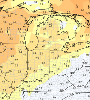
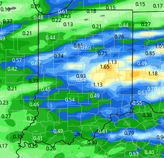
Showers develop Wednesday morning in SW Indiana and then spread over the entire state through the rest of the day and overnight. By sunrise Thursday, we should see a dry slot set up and the bulk of the precipitation will be done. Rain and thunderstorms can bring .25”-1.5” of precipitation with nearly 100% coverage, shown below. Clouds hold tough on Thursday, and we start to chill down.
Friday, Saturday and Sunday will be cold with clouds and some sun. We expect strong NW flow Friday and early Saturday which can trigger some lake effect. Precipitation will be limited to areas closer to the Great Lakes, but clouds from the lake effect will be seen in all parts of the state. Better sunshine comes in for later Saturday and especially next Sunday, but temps remain depressed. We will start to see some temperature moderation Monday the 13th.

Extended Period:
A significant system starts to build in the 4 corners region next weekend. This will kick out to the northeast for the week of the 13th, and likely sends a few rounds of rain into the eastern corn belt closer to midweek. A second batch of showers and storms follow on Friday the 17th, but the heaviest should stay just a bit farther south into the TN valley. A third front lines up for the end of the following weekend. Temps stay above normal through the extended 11-16 day forecast window.
Weeks 3 & 4:
Near normal precipitation continues for weeks 3 and 4. Temps will be near normal in week 3, and then above normal in week 4 as we flip the calendar into December.
Week 3
Precipitation (green: above normal, brown: below)
Temperatures (blue: below normal, orange: above)
Week 4
Precipitation (green: above normal, brown: below)
Temperatures (blue: below normal, orange: above)