We have about as close to ideal of a harvest forecast for the region as we could hope for in early October in my Seed Genetics Direct Harvest Weather Forecast. The only areas that we see having a hiccup will be in Michigan this Sunday, and even there we do foresee long term issues.
The pattern is dry for Indiana all the way through the 10-day forecast window. Saturday turns out sunny and dry in all areas with clouds increasing in Michigan Saturday evening. A weather system moves from Wisconsin into Michigan for Sunday, but will likely be done by midday to early afternoon. Rains will mostly stay north of I-96, but we won’t rule out a renegade shower farther south. Clouds will be in over Southern Michigan for Sunday morning and midday, as well as in northern Indiana. However, Indiana remains precipitation free.
Next week we are rain-free over the entire region from Monday through Sunday. We will be cool to start thanks to the Canadian air following this weekends northern disturbance. However, by Wednesday, we are back to warm days with fast drying. In fact, even while its cool, we see low humidity and fast drying. There will be no major issues all of next week.
Colder, Canadian air will be trying to break loose again later this coming weekend, which will set us up for a chilly finish to the weekend and start to next week. However, other than clouds, we do not expect any other consequence of the cooler air surge.
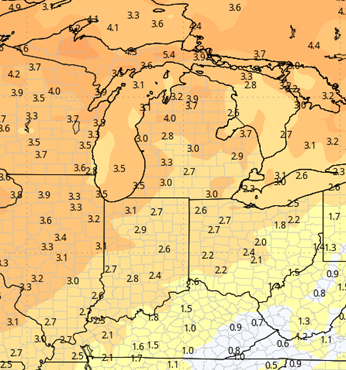
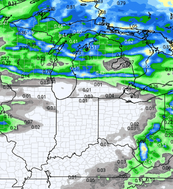
The map below shows 10-day rain totals for the region.
Extended Period:
The extended 11-16 day period continues the mostly dry pattern. As far as frontal passages go, we can throw out the potential of a minor front for the 18th, but it does not have any significant moisture with it so far and will likely just act more as a wind shift, with clouds and some cooler air. Otherwise, we are still quite dry through the 21st.
Even with a few more pushes of cooler air, we are looking to average above normal for the extended period (remember, it’s that time of year, cooler air is the norm, so we can have colder air push in and still be above where we should be at this time of year.)

Weeks 3 & 4:
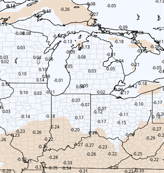
No change in the pattern of above normal temps for either week three or four. WE stay below normal in precipitation in week three but may sneak a little more moisture in as we head into early November, enough to get back closer to normal. But by then we could be mostly done with harvest.
Week 3
Precipitation (green: above normal, brown: below)
Temperatures (blue: below normal, orange: above)
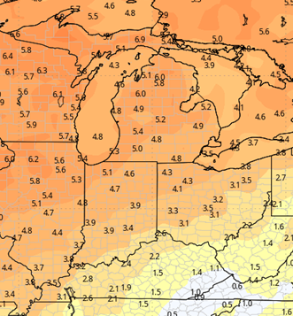
Week 4
Precipitation (green: above normal, brown: below)
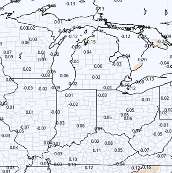
Temperatures (blue: below normal, orange: above)