[the_ad id=”98426″]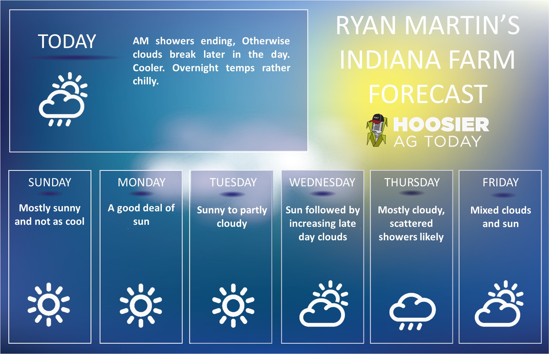 Another soggy week last week, with very few windows for field work. This week we string together longer periods of dry weather, but the question lingers as to how long it will take for conditions to be fit to return to harvest. We picked up a lot of moisture in the past 10 days to 2 weeks, and that is creating a lot of mud. We start the weekend with lingering rains for the first part of Saturday but should start to get clouds to break Saturday afternoon and evening. We expect full sun Sunday through at least Wednesday. After a cool start to this period on Saturday (we can actually see the coolest air that we have seen in a while in here for morning lows Sunday morning), we see temperatures warming Sunday through Wednesday with good evaporation and drying. Evaporation should work closer to .2” per day through the period, with temps mostly normal to above normal.
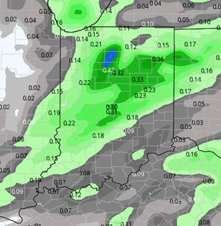 Thursday of this coming week we see moisture kicking towards us from the west. The front does not look exceptionally moisture laden at this time, but it also looks to follow the pattern that we established this week, one of a strong low moving across the northern half of the plains, into the upper Midwest, and the cold front spinning out well in front of the low, wrapping up through the great lakes. Why is this important? Mostly because this set up very easily can produce more and longer lasting precipitation than initially seen. So, while we are keeping fingers crossed for no more than half an inch out of the Thursday event, we will say the range
can run .1”-.75” with 75% coverage over the state.
[the_ad id=”100306″]
We put together a couple of drier days behind that for Friday and Saturday, as colder air drifts in from the Great Lakes to finish the weekend, we can see a few pop up showers over the state, but only a few tenths with 30% coverage.
This is not the most ideal forecast, and the rain potential Thursday is just flat out not needed. However, we believe this forecast is at least a significant improvement over the last 10 days.
Extended Period:
The extended forecast has been flip-floppy. WE still are concerned about the potential for a significant run of moisture closer to the 27th/28th. However, there is no model agreement for the extended period at all. One model has a strong system coming into the SW US that will potentially bring big time rains into the corn belt for the 28th through the 30th. Another says nothing but sunshine blue sky and dry air. While we would like to believe the latter, at this point we think that the current pattern suggests at least one system coming in here around the 27th-28th with rain chances of .25”-.75”. Temps do stay mostly above normal for the extended period. Stay tuned to Hoosier Ag Today for our updates on the potential for drier days at and just ahead of the turn of the month.
[the_ad id=”100305″]
Weeks 3 & 4:
Near normal moisture in weeks 3 and 4, meaning we see chance of showers both weeks. This does not bode well for accelerating harvest at fast pace. Temps are closer to normal but still above all the way into mid-November.
Week 3
Precipitation (green: above normal, brown: below)
 Temperatures (blue: below normal, orange: above)
 [the_ad id=”100303″]
Week 4
Precipitation (green: above normal, brown: below)
 Temperatures (blue: below normal, orange: above)
