[the_ad id=”98426″] We finally are putting together a drier forecast for harvest in this week’s harvest weather update. However, it comes as temps plummet. So, the fact that we do not see a lot of new precipitation in the next 10 days, while good news, will not yield as good of drying as we would have seen back several weeks ago. And let’s be clear…we have a lot of drying to do after an October that will finish as the 3rd wettest in history over the state.
We start off the forecast with more clouds than sun for your Saturday, but we do not see any significant new precipitation. Rains will be kept to areas farther east. We are on the backside of the strong low in PA, it having swept through our region Thursday and Friday. We keep temps mild but drying will be limited by clouds and sun potential. Sunday will be partly to mostly sunny and mild, with better evaporation and drying.
[the_ad id=”100305″]
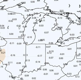
Colder air is on the move for next week. This chilly, Canadian airmass will start to sag across the Great Lakes Sunday, and the cold air is in play here starting Monday. Temps will be below normal Monday through Friday. We expect hard frosts and freezes over most of the eastern corn belt this coming week. The colder air dives far enough south that we do not see any threats of rain from warm air/cold air interaction later this week. That threat stays down over TN, KY and points south. However, this does slow drying through evaporation thanks to lower air temps. Sun will help. But still, expect soil conditions to only improve slowly. Still, this should be the best opportunity for multiple days back to back useable for field work in quite a while. The map at right shows temps compared to normal for Monday through Friday of next week.
 Temps moderate next weekend, but we remain dry over the state, and will push the open window for harvest through next weekend.
Extended Period:
While the next 10 days look pretty good, the jury is out on the extended 11-16 day window. Models stand in stark disagreement with each other for the extended period. One model brings a very wet pattern back following next weekend, and others stay dry. To us, it we feel that the outcome depends on where cold air retreats to. IF the cold air of next week pulls back up all the way into Canada, that will likely allow system development in the SW US, which will swing northeast riding strong flow off of the Gulf of Mexico. IF the cold air does not retreat as far north, the active precipitation track will stay farther to our south. So, at this time we are trending a bit cooler for the extended period and thus drier…but would urge folks not to count on a mostly dry 10 day window extending all the way through Nov 16. We think at least one system is likely to develop the second half of our extended period, and we are watching closely for something sooner.
[the_ad id=”100303″]
Weeks 3 & 4:
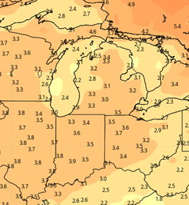
Week three is trending wetter with normal to above normal precipitation through the 21st, and week four is a little drier with normal to slightly below normal precipitation through the 28th. We warm in the later part of the forecast with week three temps well above normal, but cool off a bit for week four, as temps are only a degree or two on average above normal. See maps below. The colder air will be more of a story nearby for our forecast for next week and the week following.
[the_ad id=”100306″]
Week 3 Precipitation and Temps

Week 4 precipitation and temps