[the_ad id=”98426″]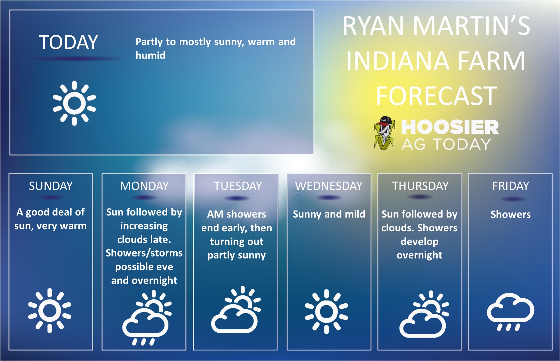 Last week did nothing to really get us excited about harvest. We dealt with way too much moisture in most locations, and when not seeing new moisture, we did not accomplish much drying either. This week will give some better drying opportunities, but still, we will need to get lucky to have a great chance at harvest.
The weekend will be sunny, warm, and dry. Summer-like temps will be seen over the entire state, and we should see decent drying, despite higher humidity levels that turn up. We also expect some stronger southwest winds to be in here Sunday and Monday of next week, aiding the drying and fueling the warmup. Monday is dry as well, but after starting with a lot of sun, clouds build late in the afternoon.
A strong cold front sweeping eastward out of a powerful in the upper Midwest to start the week will be knocking on our door as Monday comes to a close. The front is weakening and losing moisture as it comes east, but at this point we can not leave rains or thunderstorm our of the forecast. We are keeping a chance of showers and storms overnight Monday night through Tuesday mid-morning. The best threats are in western IN, and that includes the thunderstorm threats with heavier rain. From US 31 west, we will look for .25”-1” with coverage at 70%. The eastern part of the state looks to be closer to a few hundredths to .25” and 40% coverage. However, this threat can move east or west and really can’t be considered “locked in” until we get to Monday afternoon and see its strength. Hence, we won’t rule out moisture anywhere, but really are looking for some luck for this front to fall apart faster and farther west.
[the_ad id=”100306″]
We are partly sunny statewide by Tuesday midday/afternoon. While we are warm relative to normal, we will be a good 4-8 degrees cooler for the Tuesday afternoon through Thursday period than what we see this weekend. Evaporation reaches near max levels for Wednesday and Thursday. If we escape with minimal moisture out of the Monday night-Tuesday event, we have a good chance to get into or stay in the fields through this period.
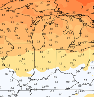
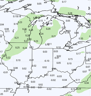
 Late in the week, a second cold front swings in from the NW. This front has not looked impressive in early model runs but seems to be picking up a bit more moisture as we get closer to the event. Right now, we are putting showers in the forecast from Thursday night through sunrise Saturday. Rain totals can be .25”-.75” over 90% of the state if this front holds together. The main driver of the boundary will be cooler air…which means precipitation is likely going to hold on in this one. Cooler air moving into a warmer, more humid airmass from the week prior will have plenty of moisture to wring out. Still, our hope is that these front rains out some of this moisture farther NW of the state. The map at right shows potential cumulative rainfall this week if we don’t miss out on either the early front or the late week one.
[the_ad id=”100303″]
Behind that front, we are dry to finish the 10 day window. Temps will be cooler, near normal, and we will see good sunshine and evaporation through Monday the 18th. In fact, high pressure will build in over the top of the state for the 18th, helping the airmass dry out further.
Extended Period:
The extended forecast is encouraging. Most of the 11-16 day window is fully dry, dominated by high pressure. There is one potential hiccup, and it happens early on, late the 19th into the 20th. Models are in disagreement, but we need to watch the western Gulf of Mexico. There may be a tropical system that tries to move up into LA and the lower MS River area….and if its strong enough that moisture can streak up from the south into our area. Its hard to put a finger on that, as tropical systems are tough to pinpoint even 4-5 days out…let alone almost 2 weeks. So, confidence is low, but we need to watch it. IF that southern surge does not materialize, we will be able to look for a dry window all the way from the 16th through the 25th.
[the_ad id=”100305″]
Weeks 3 & 4:
Precipitation for weeks 3 and 4 will turn out nearly normal. That means we can see at least one threat of moisture each week to finish October and for the first week of November. Meanwhile temps stay warm. Much above normal for week 3, backing of to only 1-2 degrees above normal for the weekly average for week 4.
Week 3
Precipitation (green: above normal, brown: below)
 Temperatures (blue: below normal, orange: above)
 Week 4
Precipitation (green: above normal, brown: below)
 Temperatures (blue: below normal, orange: above)