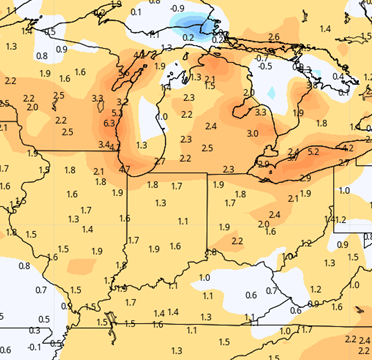
A much better planting outlook this week. Our only wild card will be how much rain specific locations pick up Sunday. Rain from Saturday night through Sunday will range from .25” to 2+”. The heaviest will be in central and southern IN. The northern third to quarter of the state will be in the lower end of the range. Coverage will be 100%. See map below. However, behind that rain, we are fully dry for next week. Monday through Friday we see rain free conditions statewide. Saturday and Sunday we can’t rule out a few minor showers in SW IN, but the rest of the state stays dry. That means many locations will be looking at the potential of 7 days of dry weather. We should see full sun as well. Temps will be cool to start for Monday and Tuesday, getting to near normal for Wednesday and Thursday, and then be normal to above normal for Friday through the weekend. That will promote good evaporation and dry down, with evaporation averaging .2”-.25” per day the first half of the week and potentially near .3” for late week. Areas that were at the low end of Sunday’s rain range should be looking at some field work by midweek or sooner, while heavier Sunday rains will push that back to late week…but tractors should be able to roll in most areas at least a little bit this week.
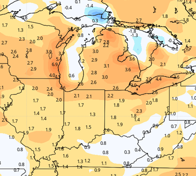
Next week we see a strong front working out of the eastern plains into the western corn belt and will look for some potential showers late Monday or Tuesday. The moisture does try to break apart a bit before getting here, so we are pegging those rain totals at .1”-.6” with coverage at 75% right now…but will tweak as we get closer to the event.
 Extended Period:
Showers mentioned above to finish the 10 day period may linger through Wednesday the 19th, perhaps adding another .1”-.3” with 75% coverage. However, then we are back to dry weather Thursday the 20th through Sunday the 23rd. So, as long as rain totals stay minor, we have a decent shot at field work there.
Weeks 3 & 4:
An active precipitation track develops over the corn belt from I-80 north into week 3. Rains will be above normal across the upper Midwest into the Great lakes, and we may see some of that sag south into IN. Then we likely keep rains near to above normal wo finish May and go into early June. Temps will be a good 1-3 degrees above normal for the last week of May and the first week of June.
Week 3
Precipitation (green: above normal, brown: below
 Temperatures (blue: below normal, orange: above)
 Week 4
Precipitation (green: above normal, brown: below
 Temperatures (blue: below normal, orange: above)