Temps finally bounce in this planting forecast. The first step in moderating temps comes this weekend. This will be a subtle move, as we also see some moisture moving across the state. However, we will be a far cry from where we were last Wednesday! Rain for Saturday became less impressive recently, and we are projecting a few hundredths to .4” over 60% of Indiana. We turn out partly sunny behind the Saturday morning for Sunday, but temps will also stall at slightly cooler levels. We should start to see some decent evaporation
Monday and Tuesday feature a dramatic push higher in temps. We will be above normal Monday and well above normal Tuesday with strong southwest winds. This will promote excellent drying both days. Temps Tuesday will run from upper 70s to mid and upper 80s statewide. This is window number 1 for planting that we see.
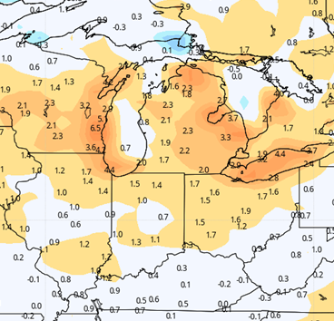
Now, heat at this time of year, especially following on the heels of significant airmass change usually produces instability. This will be no different. That instability brings scattered showers and a few thunderstorms next Wednesday ahead of a cold front that comes Thursday. That front also brings showers and storms. Two day rain totals look at this point to be .5” to 2+” with coverage at 90% of Indiana, see map below. This will be a significant rain event. Now, the super heavy and severe thunderstorms look to stay farther west over IL, WI, IA and MO, but general thunderstorms are likely anywhere in the state over these two days, and that will be enough to really potentially boost totals.
Behind the front, we move into a dry period to finish the 10 day window, with at least 5 straight dry days through Monday the 3rd. Temps stay warm at normal to above normal levels. Evaporation will be at a near maximum for those days. We will see opportunity to return to the field to plant in that stretch, but how soon will depend on each of your respective rain totals from the Wednesday-Thursday timeframe.
 Extended Period
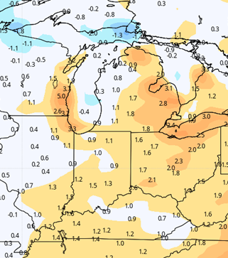
We extend that dry window at least 2 more days in the 11-15 day period. The next front we need to pay attention to comes together overnight Wednesday the 5th through early Thursday the 6th. Rain totals look manageable, at .25”-.75” with coverage at 80%. We return to partly sunny skies for Thursday afternoon through Friday, and temps stay warm. We can’t rule out showers and storms returning with a strong front to end the extended window for Saturday the 8th and Sunday the 9th. Preliminary looks suggest half to 1” potential.
Weeks 3 & 4:
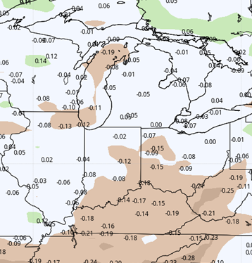
We continue to see an active precipitation pattern for week 3, but dry down for week 4. 2 systems with half inch potential will work through the area in week 3, but we may see .25” or less for week 4. Temps will be above normal both weeks, averaging 1-2 degrees above normal for the weekly averages each week.
Week 3
Precipitation (green: above normal, brown: below)
 Temperatures (blue: below normal, orange: above)
 Week 4
Precipitation (green: above normal, brown: below
Temperatures (blue: below normal, orange: above)